New weather radar system hoped to fill gaps, improve forecasts
October 21, 2021
More X-band radar stations are coming to the San Francisco Bay Area region. Their installation continues the implementation of a weather forecasting system to detect atmospheric rivers, which would give emergency planners more time to prepare before a sewage plant overflow or a mass transit station flooding.
Atmospheric rivers (ARs) are described as “huge airborne bands of water that travel thousands of miles across the Pacific Ocean and bring extreme weather” in the form of intense rain and snow events to the western states of California, Oregon and Washington. Not much is known about the weather phenomenon, which may be responsible for up to half of the region’s rainfall.
Apart from the West coast, ARs are known as atmospheric water vapor transport.
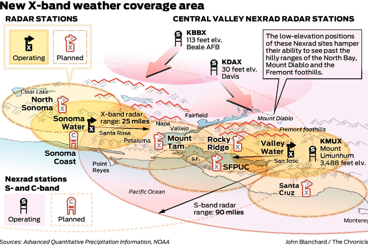
Advanced Quantitative Precipitation Information (AQPI) system
With a $20 million grant from the California Department of Water Resources (DWR), rollout of the $31 million Advanced Quantitative Precipitation Information (AQPI) system continues. The system began in 2018 with a Sonoma County station installation, followed by one in San Jose. By December, 2021, East Bay will be online. By 2024, the region will be home to four more stations near dense urban areas, including one in Santa Cruz.
Research meteorologist at the National Oceanic and Atmospheric Administration (NOAA) and AQPI technical lead Robert Cifelli believes the system can reduce the annual cost of flood damage in the SF Bay Area by $60 million if atmospheric rivers can be seen “coming many days in advance, exactly where (they’re) going to hit and how intense (they’re) going to be.”
Weather radar sends out radio signals that hit raindrops and bounce back. Data helps map location, intensity and direction of the rainfall.
X-band vs. S-band vs. C-band
AQPI is designed to provide intensity and location details. Its X-band radar stations cover more ground and provide higher-resolution, crisper images with more frequency – every two minutes compared to every six minutes – than the existing Nexrad S-band network. Currently, four main S-band stations inform most SF Bay Area weather forecasting. An S-band station atop a mountain can miss rainfall at lower elevations because the radar beams may skirt over a city at “too high an elevation (due to) the curvature of the Earth,” or mountains may block signals from a station at a lower elevation.
Since the current radar system is “limited by hilly topography;” the smaller range X-band signals will “fill as many gaps as (they) can” said Cifelli. Varying terrain with deforested burn scars and flood risks posed by atmospheric rivers make Sonoma County’s Russian River Valley particularly vulnerable. Higher-resolution images could indicate where heavy rain is more likely to cause debris flows, mudslides, and flooding.
One new station uses C-band radar, which has a larger range than X-band. Once installed on the Sonoma coast as a complement to C-band stations on Mount Umunhum and Eureka, it will face the Pacific to monitor atmospheric rivers and less severe weather events as they head toward Marin, Sonoma and Mendocino.
More forecasting inputs
After all six radar stations are installed, NOAA anticipates the more time will be needed for the AQPI system to truly improve weather forecasting.
Nonetheless, the combination of real-time information from many sources such as in-situ rain gauges can improve the capabilities of nowcasting — or forecasting for the next 30 to 60 minutes, which can be critical to emergency management.
When all this hydrometeorological information is fed into models, meteorologists and flood control professionals can continually improve upon both the accuracy and precision of weather predictions over several hours and days. Additional lead time before a storm is important to stabilize burn scars, warn communities, inform evacuees, prevent flooding damage and protect lives.
More accurate forecasts can also help water managers optimize reservoir operations or water storage for more effective water management, especially as drought persists.