Water, Weather & Environment
Establishing a collaborative flood forecast system
Enhancing flood forecasting to reduce the risk of weather-related deaths & loss
To support the first (U.S.) National Water Model that identifies at-risk populations and informs flood warning & evaluation decisions, Esri and KISTERS released a National Water Model demonstration project to fulfill their joint commitment to the White House.
As global leaders in integrated geospatial and time series information systems, Esri and KISTERS have integrated flood-relevant data from local and national sources into the model.
The management of data-processing and spatial-analysis workflows advances streamflow and flood inundation forecasting for 2.7 million stream reaches and 6,600 sub-basins in the U.S. upon full implementation of the model. The combination of forecasts and other pertinent information will be freely available online and visualized through interactive online-mapping applications.
Download a 2-page summary- The challenge
- The solution
- The benefits
The challenge
The challenge
The expanse of monitoring flood risk across the United States makes difficult the equitable provision of operational forecast streamflow guidance.
To meet the needs of underserved locations and deliver fully continuous, 24/7/365 analyses and forecasts of the nation’s surface water, a seamless interface of real-time hydrologic data and data products within an advanced geospatial intelligence framework needed to be established.
In addition, the rapid infusion of critical observation data would need to be increased from about 3,600 current river forecast points to NWM 2.7 million forecast points.
The solution
The solution
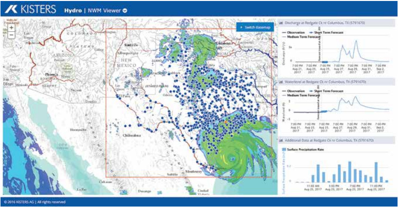
KISTERS developed a demonstration project using National Water Model (NWM) forecasts for flood impacts at stream and street level.
NWM forecasts from the National Weather Service are ingested into KISTERS big data technology stack, which compares the forecasts to federal, state, and local stream gauge data. KISTERS utilizes rating curves computed using the Height Above Nearest Drainage (HAND) method developed by the University of Texas at Austin to convert forecasted flow to forecasted water level.
KISTERS web interoperability services give advanced data users the ability to consume, transfer, and publish information over the Internet in real time. Using open data standards like WaterML 2.0 and SOS make API options available via HTTP for fast and efficient dissemination as well as retrieval and calculation of data.
Using the web services, KISTERS supplies forecasted flow and precipitation, computed water level, and evaluations of forecast data versus actual gauge measurements to Esri for geoprocessing and the creation of inundation maps and dashboards.
The benefits
The benefits
Authorized groups and individual users are able to access specific parameters or all information directly from associated database(s).
Each stream reach and HAND elevation are associated with emergency response address points to provide actionable information products. Emergency management professionals can easily view approximate flood levels and address inundation using NWM 18-hour (short-term) and 10-day (mid-term) forecasts.
The NWM Web Portal and Data Viewer created by KISTERS allows users to view and compare all data supplied by the web services for complete transparency.
Alternatively, the public can access shorter, more concise amounts of data in near real-time. Daily, weekly, monthly or annual data on flow, stage, precipitation, etc. can be displayed in multiple browsers in addition or embedded in existing websites.
Share this
The National Water Model system set up with Esri and KISTERS shows that the technology -- given hydropoints, computing, and a cascade of subsequent computations that translate forecast weather into forecast impact -- gave an accurate strategic assessment of where damage would happen and the hurricane at the time it made landfall.
Dr. David Maidment, Civil Engineering Professor Emeritus at The University of Texas, Austin in Austin, Texas, USA