
Wasser, Wetter, Umwelt
Monitoring water level from glacier lake outburst floods.
U.S. federal agency adopts water observing tech, strengthening public safety.
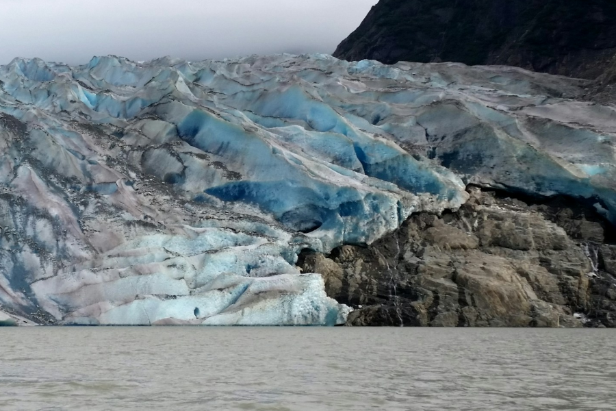
The Mendenhall Glacier once fanned out across the lake it carved and imparted its name. NASA observes that although the glacier began retreat centuries ago, satellite imagery shows accelerated ice loss since 2011 with the warming temperature. Rapid glacial retreat is causing annual and increasingly severe glacier lake outburst floods (GLOFs) or jökulhlaups (pronounced yah-cuh-laups), which occur when meltwater stored by glaciers or moraines is released abruptly. Basically, ice dam failure. About 13 miles upstream from Alaska’s capital region of Juneau, Mendenhall GLOFs pose significant risk to public safety, threatening the Mendenhall Valley population, tourists, and property.
- The Challenge
- The Solution
- The Benefits
The Challenge
The Challenge
- A third of previously documented GLOFs globally have occurred in Alaska. Monitoring recurring and increasingly severe glacier lake outburst flood events caused by rapid retreat of both the Suicide Glacier and the Mendenhall Glacier is essential.
- Increasing satellite image availability reveals no significant increase in frequency. A satellite-based approach alone suggests that outburst floods have historically been under-reported.1
- Two consecutive years of GLOFs have had unprecedented water levels, extreme peak discharges and significant erosion. For example, the August 6, 2024 event reached 42,700 cubic feet per second (cfs), vastly exceeding a 500-year flood event baseline of 26,060 cfs.
- Despite GLOF events with the same stream gage water level rise, the dynamic nature of evolving glaciers, river hydraulics and geometry can produce vastly different downstream impacts.
- Mitigating risk to Alaska’s largest populations requires advanced planning.
The Solution
The Solution
To better prepare for glacier lake outburst floods, Alaska is strengthening flood monitoring systems to improve both situational awareness and emergency management coordination. Water, weather and environmental monitoring data over time will help scientists anticipate GLOFs and coordinate with organizations to prepare by adapting drainage infrastructure and enabling direct notification to evacuees, if necessary.
The USGS – Alaska Science Center mission is to measure water and provide data for scientific partners, such as the National Weather Service Juneau and University of Alaska Southeast to utilize.
In June, 2026 the Juneau, Alaska field office purchased and installed a KISTERS HyQuant L+V water radar sensor. The 2.5 lb (1.15kg) sensor was relatively light to carry into the remote monitoring site. Mounting the radar above Mendenhall River would enable hydrologists to safely and continuously monitoring the water level and surface velocity. Reliable collection of real-time observations would complement the network of cameras, drones, and aerial flights focused on glacial behavior.
By June 30, 2026 the sensor was deployed at and relaying stage information from USGS stream gauging site 15052850 (Mendenhall R BL Montana C NR Auke Bay Alaska). Area hydrologists were receiving precise, real-time hydrologic monitoring data – readily observing rapid water level fluctuations and river dynamics.
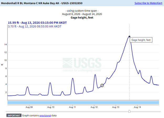
On August 13, 2026 at USGS Station 15052850, the HyQuant radar recorded a peak of 15.99 ft at 3:15 PM AKDT.
The Benefits
The Benefits
As glacial dynamics increase flood risks to downstream communities, use of robust monitoring instruments is critical to lead time and decisions. Advanced radar sensing technology like the HyQuant delivers accurate, real-time water data and insights into complex river hydraulics to organizations working together.
Both the National Weather Service Juneau and University of Alaska Southeast to utilize USGS water measurements. The latter is trying to start a project to model GLOFs on decadal timescales.
In addition, the U.S. Army Corps of Engineers Flood Fight Materiel Center (NFFMC) can more efficiently plan and ship supplies to support flood mitigation efforts from multiple staging areas, across multiple USACE divisions.
Improved situational awareness, early warning communication and intergovernmental operational efficiency greatly enhance community preparedness – reducing potential harm to life and property.Not every retreating glacier in Alaska is at risk for these glacial lake outburst floods, but other basins could emerge as new threats. USGS and researchers are monitoring potential new basins and their risks.
1 B. Rick, D. McGrath, S.W. McCoy and W.H. Armstrong, “Unchanged frequency and decreasing magnitude of outbursts from ice-dammed lakes in Alaska,” Nature Communications, 2 Oct 2023, https://www.nature.com/articles/s41467-023-41794-6
2 “Mendenhall Glacial Lake Outburst Flooding Technical Report,” U.S. Army Corps of Engineers Alaska District Website, https://www.poa.usace.army.mil/Missions/Civil-Works-and-Planning/Mendenhall-Valley-Technical-Report/