Skip to content
>

Data-driven Sustainable Groundwater Management

a single platform for maximizing data on groundwater resources

photo of well lithology information or lithologic classes (mineralogical and physical properties of rocks) | source California Department of Water Resources, a KISTERS customer

Unify decision-support for groundwater supply & protection

Manage groundwater resources and protect water quality
by centralizing data from any sensor or source with
a long-term groundwater data management platform.

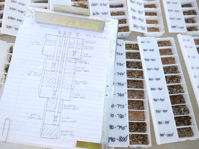
Get a comprehensive understanding of your underground water resources with WISKI
as  hydrological data, well logs and pumping data are stored and validated.

Analyze groundwater level measurements with precipitation and surface water data
— over weeks, months, seasons, years, even decades of observations.

Uncover more benefits below.

Benefits

1

Analyze aquifer performance test results

Run aquifer performance tests and immediately process results with built-in rating curve tools, designed by hydrogeologists and water resource engineers.

2

Record quantitative parameters

Record an extensive number of parameters including measurements such as the top of casing heights, hydraulic conductivity, and transmissivity.

3

Review qualitative parameters

Test hypotheses with metadata on clouding/turbidity, chemical and physical descriptions, drill profiles, extension plans, and maps.

4

Download drill profiles

Setup dropdown lists for chrono, litho and stratigraphic classifications based on national and international standards. Or define profile fillings with symbols, color, and standards.

Enable one-click download of drill profiles as PNG, JPG, PDF, or SVH vector image files.

5

View data from the same well or adjacent wells

Using an online wellhead protection viewer, quickly view and compare measurements from different depths of the same well. Alternatively compare data from the same depth across a group of wells in the vicinity.

Even establish virtual monitoring wells.

6

Automate user-defined alarms

Continuous water level sensors and water quality probes integrated with WISKI. Set alarms on raw data values or results of water balance calculations and statistics to empower ambitious assessment and response to avoid groundwater depletion.

Mojave Water Agency logo: a brown straight line above a dark blue wavy line and a medium blue wavy line

Facing unpredictable rainfall, gathering more data & advancing scientific understanding of the region's water resources are more important than ever. Modernizing our data system maximizes knowledge transfer and enhances the work of our staff.

Mojave Water Agency

select agencies using WISKI to manage groundwater data

Ready to sustain groundwater?

Tell us your goals.

Request a free demo