Canada1Water completes Phase 1 of 2
August 12, 2024
Canada1Water leaders have successfully completed phase 1 of the Canada1Water (C1W) initiative. Natural Resources Canada’s Groundwater Geoscience Program and Aquanty Inc., a KISTERS collaborator, launched the project in 2021 to fill a critical void.
Need for a continental-scale framework
“Even though Canada has the world’s third-largest store of renewable freshwater… up to now there’s been no complete picture of groundwater, surface water and climate interactions across the country,” asserted Dr. Ed Sudicky, principal founder of Aquanty. He is also Professor Emeritus of Quantitative Hydrogeology at University of Waterloo.
To address the long-term sustainability of Canada’s water resources, they have developed the “first continental-scale, groundwater-surface water modelling platform integrated with climate and land use change information to inform understanding and decisions on the sustainability of Canada’s water resources”.
2020 marked the completion of the first version of the Canada Continental Scale Model (CCSM). It demonstrated large-scale ground/surface water interactions and water balances. Modelers are proud to include regions with “extremely sparse hydrologic monitoring data… where climate change impacts are anticipated to be most severe”.
Today the C1W model integrates groundwater, surface water, and climate. It covers a total land mass of 12 million km², including all Canada–U.S. transboundary watersheds. It encompasses more than 40,000 streams and rivers and over 7,000 lakes. Several scientific and technical problems solved in Phase 1 mark significant advancements in many areas of hydrological and climate modelling.
Canada1Water portal
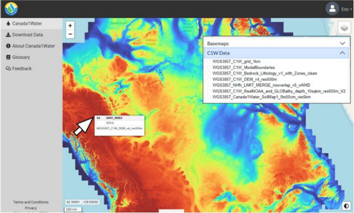
The framework is based on Aquanty’s HydroGeoSphere platform, dating back to 2009. Researchers, policymakers, community organizations, and even nontechnical member of the public are urged to take interest in Canada’s water future. To that end, C1W datasets and model outputs are freely available via the C1W data portal. The web site features geospatial interactivity. Users can pan or zoom to areas of interest, click on indicators and interact with tiled datasets at 1ºx1º resolution. Portal development will include “full model simulation results and downloadable datasets with metadata and links”.
A promising start
Dr. Hazen Russell of Geological Survey of Canada observed, “With Canada1Water, we can now start to generate national groundwater indicators and gain a complete and accurate understanding of Canada’s water resources. To manage Canada’s water resources, we need good information, a full picture of the active processes. Canada has been missing a key piece of the puzzle without accurate groundwater input to the modelling of surface water. This has been a significant shortcoming because groundwater provides approximately 50% of surface stream flow for many Canadian rivers.”
Shusen Wang, Sr. Research Scientist with Natural Resources Canada, “Our work is focused on developing a holistic picture of the water cycle over Canada’s entire landmass — closing the water budget for the whole country, which has never been donebefore. That’s going to help policymakers make better-informed decisions, and will give scientists, researchers and water resource managers a fuller, clearer picture of conditions to work with.”
Phase 2 Now Underway
After securing funding from Natural Resources Canada, Aquanty and Natural Sciences and Engineering Research Council of Canada (NSERC) supported universities began Phase 2 in April, 2024. The scope of work includes further analysis of C1W model outputs, running new scenarios, and developing nested models. Moreover, they will study cold-climate hydrology, permafrost and large lake effects unique to northern climates — and Canada, in particular.