Water flow sensors overcome water measurement hurdles
January 12, 2024
In general, single sensor, stationary flow measurements require steady flow conditions. These are conditions are met if the water course is straight for at least five times the river width, in the upstream and downstream directions. However, many rivers aren’t straight. Topography alter the path of a river, so flows through large and small bends are more common than not.
In addition to a curvy water course, an additional water inflow will require up to 10 times the river width until the river flow reaches steady conditions again for stationary flow measurements to be captured.
Both river curves and confluences create challenging conditions that require an innovative monitoring solution for flood management.
Multiple flow sections enhance accuracy
To confront this challenge, Kisters sought a partner that specializes in noncontact flow monitoring. Faced with monitoring serpentine rivers and converging waters, Sommer has designed its standard RQ-30 water flow sensor to serve as a stationary mobile instrument ready to monitor the water flow of small and large rivers alike.
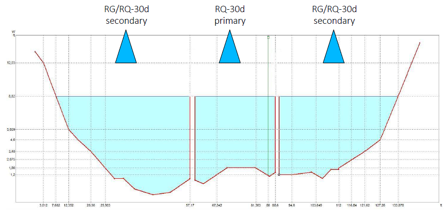
Where a river has a very heterogeneous flow pattern, sometimes a single sensor is unable to accurately measure the water flow. The enhanced RQ-30d water flow sensor has features common to the popular RQ-30 and combines a section-by-section approach with artificial intelligence (AI) to meet the most challenging flow conditions.
The multi-sensor system uses a primary-secondary concept, meaning multiple secondary devices communicate with a primary device that controls the required measurement tasks. Each secondary device monitors the water flow of a subsection of the river cross-section and the primary device computes the total flow. In this way, an irregular flow pattern is divided into multiple parts and each part is more homogeneous.
We recommend contacting us if you have a particularly difficult site to monitor. Given that the ideal setup would deploy three or four units, installing two units (one primary and one secondary) to monitor the total width of the river could be a feasible compromise between accuracy and cost.
Al tames difficult flow conditions
To alleviate the effects of difficult flow conditions, the RQ series is equipped with various artificial intelligence (AI) features.
The noncontact radar sensors are able to handle flows at both very low and high water levels. In addition, interference of wind-generated ripples unrelated to the actual water flow can be eliminated. This benefit is especially crucial when water levels are low or flow is super-slow, conditions under which wind may have greater impact on the water surface.
During high flow conditions, the AI feature becomes redundant thanks to the quality of the Sommer hydraulic model programmed within RQ sensors. The monitoring architecture within the AI-enabled RQ-30d devices offers a single point of access to all sensors and allows interfacing with any long-term data management system, including KISTERS software.
An energy efficient, reliable dataflow
Once a site is chosen, reliable data logging, transmission and alerting settings must be set up.
If a power source is unavailable on the bridge where the sensors are mounted, an autonomous solar power supply with rechargeable batteries can be installed. RQ flow sensors feature an advanced power-saving mode, which is activated between measurements. Combined with a MRL datalogger, the power consumption of the entire monitoring station could be reduced to less than lmA in idle mode. This design feature prolongs battery life and enhances reliability.
The MRL datalogger triggers the recording of measurements — acquiring level, velocity and flow data — and the sending of notifications by SMS / text and email, if predefined limits are exceeded. Additionally, the datalogger regularly transmits acquired data to the cloud, which pushes alert messages to social media platforms such as X (formerly twitter) or Telegram.
The same datalogger also collects and transmits images captured by a connected camera, providing a visual confirmation of time series measured at the monitoring site.
Thus, flood duty staff are continuously updated and have lead time to inform emergency managers and the public in the event of an approaching flood.