Water Velocity: Critical to flood warning
August 22, 2023
Why is the measurement of velocity so critical when it comes to flood warning?
The following account is courtesy of J.J. Gourley, Ph.D., Research Hydrologist with NOAA/National Severe Storms Laboratory, who shared his experience with senior colleagues the morning after a flood event on May 19, 2017 on Falls Creek, near Davis, Oklahoma. A potentially catastrophic flash flood was averted at the Falls Creek Youth Campground, located downstream of a new early flood warning system featuring a noncontact radar sensor that continuously measured both water level and velocity.
May 20, 2017
Dear colleagues,
I wanted to give you a brief summary of the flash flooding event on Falls Creek, OK (near Davis, OK) from last evening.
 In the (time series at right), you’ll see that the FLASH system was producing unit discharge values > 10 cms/km2. This is well above the threshold we consider when training forecasters. Typically, we see LSRs with values as low as 1-2 cms/km2.
Catastrophic events have values in the double digits. Note that this product was valid at 01:30 UTC.
Falls Creek happens to be the first site we deployed a stream radar system, funded by OAR JTTI project.
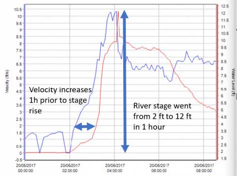
The intention is to provide an early alert for the Falls Creek Youth Campground, which hosts thousands of campers during the summer months. You can see in the time series that the velocity jumped about an hour prior to the river stage, indicating the importance of measuring velocity on rivers (also reveals likely hysteresis in the rating curve). The FLASH forecast model provided > 2 hours of lead time prior to the river stage crest at 12 feet. Note that the river rose 9 feet in 1 hour!
Several of us on the team were watching this event in real-time last night and I was regularly texting with the camp director, down there, about the life-threatening situation. His replies were: “Yes. We are flooded over all of our bridges on grounds”, “Creek is out of its banks throughout camp”, and lastly, “Thank you. All are well”.
All in all, this was quite a success story from the perspective of forecasting, observing, and communicating the threats associated with a potentially disastrous flash flooding event at night in a campground.
We will be studying this event in greater detail throughout the coming weeks.
JJ